Network Architecture
Excerpt from "Hastily Formed Networks for complex humanitarian disasters"
After action report and lessons learned from the Naval Postgraduate School's response to hurricane Katrina.
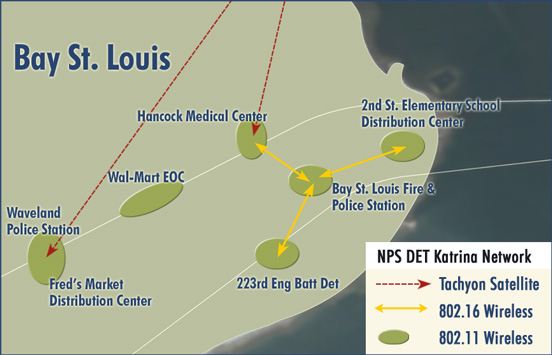
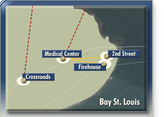
The NPS HFN supporting Hancock County, MS evolved from one node providing voice and data connectivity to first responder organizations located in the parking lot of HMC to seven nodes with hundreds of users at the county hospital, local government offices, police/fire stations, temporary emergency services locations, and department store parking lots turned into PODs and victim shelters. Figure 8 shows the overlay map of where the NPS network nodes were located as of 20 September 2005. By this time, there were two Tachyon satellite feeds; one located at HMC and one at the Waveland PD. Tachyon (a San Diego SATCOM service provider), through NPS liaison, was commendably providing free broadband Internet access for both of the terminals for the duration of the deployment. Each provided a 2MB downlink and 512KB uplink. The Waveland satellite link provided access to the "cloud" for both the Waveland PD and Fred’s POD. The HMC satellite link provided connectivity to the "cloud" for HMC and three additional locations in Bay St. Louis: the fire/police station, the 2nd Street Elementary School Shelter, and the 223rd Engineering Battalion Detachment. The NPS Team supplied a limited number of laptops and VoIP phones at the various locations, which provided Internet and voice connectivity.
 Figure 8. Actual Network Node Locations (as of 20 September 2005) |
Figure 9 shows the logical network layout as of 15 September 2005 (Visio
drawing provided by Karen Easterbrook of Microsoft, who was on the ground
with the Katrina Team for several days, offering help wherever needed).
This better illustrates the equipment and services provided at each end user
location. All sites provided Web, email, and VoIP services.
Read full document here: NPS Katrina AAR/LL (PDF, 5.4MB).
(The above excerpt was taken from chapter 2, Network Architecture, pages 27-37).
